Thanks to maps.Google, we are now plotting our motorhome trip segments so that people can see where we are and the route we've taken to get there. Using the maps.google interface, you can see the map in three modes: street map, satellite (terrain), or a hybrid of both. Click on a marker to see where we stay, along with a picture of our RV there. I will try to add other markers to display photos of interesting places nearby that we've visited. I've also included video showing some of the trip legs using our RV Cam. I'm working on incorporating GPS into each photo. Since we are on the road full time in our RV, a trip is a pretty arbitary designation. I'll define the trips as I see fit, usually from one long stop to another. HERE's A SAMPLE MAP of our Motorhome trip: |
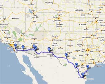
Click on the link below to see our actual trip route on maps.google.com:
NEW and Cool !! Click here for my new Google Interactive Highway Maps feature with thousands of images.
Trip Segment | Dates | Our mobile RV Cam movies for this trip. |
Ramona, CA to Boone, NC. | Start March 2007, Finish, May 2, 2007 | to Yuma, AZ to CasaGrande,AZ to Deming, NM to Fort Stockton, TX to Del Rio, TX to Mission, TX to Houston,TX to Alexandra, LA to Meridian, MS to Greensboro,GA Gaffney, SC to Lenior, NC to Taylorsville, NC |
Lenoir,NC to Island Park, ID | Start May 17, 2007 Finish June 1, 2007 | to Williamsburg, KY to Monticello,IN to Naperville, IL to Spring Grove, MN to Rapid City, SD |
Island Park, ID to Ramona,CA | Start Sep 28, 2007 Finish Dec 26, 2007 | |
Lytle Creek CA to Island Park, ID | Start Mar 28,2008 | |
DISCLAIMER: the route we take is not our recommendation to you and we accept no responsibility for any problems you encounter if you decide to take the same route. Always research the route you take for it's suitability for your own size rig, it's handling capability and your driving capability. If you use GPS Navigation device, make sure you use common sense when following it in a large motorhome. Check a truckers atlas for safety and clearances. |